banniere TrackandRoad
| Connect

Aidez le site : faites un don Paypal

Deutsche Alpenstrasse (eastern part)

Take part

Don't forget to publish your favourite biking roads.

Use Motorbike-roadbooks

You can create custom roadbooks based on these roads by using software Motorbike-Roadbooks. For a first use, you can have a look at the tutorial.

Map

Zoom back to initial map

Description

Well, this road is called Certes AlpenStrasse, but that doesn't mean you'll ride vertiginous pass. Nevertheless, you'll for sure enjoy riding through lakes, forests and other charming places.

An extra for the (tolled !!) road beetween Wallgau and Achenpass, it is very nice ! The rest of the way is well surfaced, with OK curves, but be careful, it might be overcrowded during summer time.
Pictures

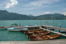
Tegernsee
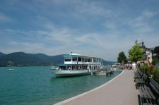
Tegernsee (2)
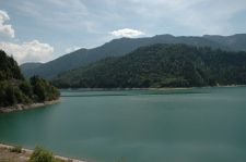
Sylvenstein-Tausee
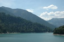
Sylvenstein-Tausee (2)

Marks

The roadbook

133.3 km (about 2 h 08 min)

Stage Instructions Distance Zoom crossing
Garmisch Partenkirchen 0 km
1 Head east on Rathausplatz PK : 0 km
(-> 0 km)
2 Slight right to stay on Rathausplatz PK : 0 km
(-> 0 km)
3 Slight right at B2/Hauptstraße
Continue to follow B2
PK : 0 km
(-> 14.5 km)
4 Slight right to merge onto B11 toward Wallgau/Krün/München/Kochel PK : 14.6 km
(-> 3.8 km)
5 Turn right at B11/Walchenseestraße PK : 18.4 km
(-> 0.4 km)
6 Turn right at Risser Str.
Partial toll road
PK : 18.9 km
(-> 12.8 km)
7 Turn left at B307/Vorderriß
Continue to follow B307
PK : 31.7 km
(-> 10.2 km)
8 Turn right to stay on B307
Entering Austria
PK : 42 km
(-> 5.5 km)
9 Continue on B307
Entering Germany
PK : 47.5 km
(-> 0.3 km)
10 Continue on B307
Entering Austria
PK : 47.9 km
(-> 1.3 km)
11 Continue on Achenwald/B181 PK : 49.2 km
(-> 0 km)
12 Turn left to stay on Achenwald/B181 (signs for B181/Tegernsee)
Continue to follow B181
Entering Germany
PK : 49.3 km
(-> 1.2 km)
13 Continue on B307/Stuben
Continue to follow B307
PK : 50.5 km
(-> 13.6 km)
14 Turn left
Destination will be on the left
PK : 64.1 km
(-> 0 km)
15 Head south toward B307 PK : 64.2 km
(-> 0 km)
16 Turn left at B307 PK : 64.2 km
(-> 12.4 km)
17 Turn right at Schlierseer Str./St2076
Continue to follow St2076
PK : 76.7 km
(-> 8.6 km)
18 Turn left at Naturfreundestraße/St2076 PK : 85.4 km
(-> 0 km)
19 Turn right at B307/Schlierseer Str.
Continue to follow B307
PK : 85.4 km
(-> 17.6 km)
20 Turn right at St2075/Tiroler Str. (signs for Kufstein)
Destination will be on the right
PK : 103 km
(-> 0 km)
21 Head north on St2075/Tiroler Str. toward Alpenstraße/B307 PK : 103 km
(-> 0 km)
22 Turn right at B307/Deutsche Alpenstraße
Continue to follow B307
PK : 103 km
(-> 10.6 km)
23 Turn left at B307/Deutsche Alpenstraße PK : 113.7 km
(-> 1 km)
24 Turn right at RO52 (signs for Oberaudorf/Niederaudorf)
Destination will be on the right
PK : 114.7 km
(-> 7.8 km)
oberaudorf 122.6 km

Nearby roads

  • See roads closer than : kms

Research radius : 100 km

Road Length Distance / Active road Mark
Grossglockner - Hochalpenstrasse 69.7 km 65 km 4.5/5
Col de la Silvretta 28.4 km 90 km 4/5
Col du Timmelsjoch - Rombo (2509 m) 51.3 km 59 km 3.9/5
Au bout du Tyrol 31.7 km 87 km 3.9/5
Gerlospass (1628 m) 61.2 km 48 km 3.8/5
Grand prix d'Autriche de Superbike 62.3 km 31 km 3.6/5
Jaufenpass 33.9 km 71 km 3.6/5
Riedbergpass 25.9 km 65 km 3.6/5
Passo Staller 36.9 km 86 km 3.5/5
Deutsche Alpenstrasse (western part) 150.2 km 7 km 3.3/5

Nearby Accomodations

  • See accomodations closer than : km

There is no accomodation closer than 100 kms. Increase research radius (max 250 km).

Your opinion

There is no opinion about this road yet.