banniere TrackandRoad
| Connect

Montets pass(1461 m)

Take part

Don't forget to publish your favourite biking roads.

Use Motorbike-roadbooks

You can create custom roadbooks based on these roads by using software Motorbike-Roadbooks. For a first use, you can have a look at the tutorial.

Map

Zoom back to initial map

Description

Another interesting Alpine pass. It's not very long, the Atrgentière side climb has some funny curves, but the downhill towards Vallorcine is not so funny.

Surfacing is good, but, what is really worth riding it is the view of the Mont Blanc chain and Argentière ice field.

Pictures

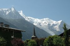
Le mont blanc à Chamonix
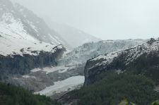
Glacier d'argentière

Marks

The roadbook

13.8 km (about 16 min)

Stage Instructions Distance Zoom crossing
Chamonix - Les Praz 0 km
1 Head northeast on D1506/Route des Tines toward Route du Golf
Continue to follow D1506
PK : 0 km
(-> 13.8 km)
Vallorcine 13.8 km

Nearby roads

  • See roads closer than : kms

Research radius : 100 km

Road Length Distance / Active road Mark
Le Col de Frene 10.1 km 69 km 3.8/5
Cormet de Roselend pass (1968 m) 39.3 km 34 km 3.7/5
Route des Saisies 32.2 km 34 km 3.7/5
Vers le Lac Genin 11.1 km 92 km 3.7/5
Pas du Frou 10.4 km 99 km 3.7/5
Iseran pass 47.2 km 55 km 3.6/5
La piste du col de la Finestre 57.7 km 90 km 3.5/5
Traversé de la Chartreuse 62.5 km 85 km 3.5/5
Télégraphe and Galibier pass 42.9 km 87 km 3.4/5
St Laurent - Lac de Vouglans 38.4 km 96 km 3.4/5
Aravis pass (1487 m) 18 km 31 km 3.2/5
Simplon pass (2005 m) 47.7 km 87 km 3.2/5
Tarentaise valley 24.4 km 37 km 3.2/5
Jaunpass 15.4 km 68 km 3.2/5
Gorge des Eveaux (A40 -> la Clusaz) 17.2 km 37 km 3.1/5
Biche pass - Grand Colombier mountain 33.1 km 81 km 3.1/5
Col du Mont Cenis 40.6 km 73 km 3.1/5
La Furkastrasse 37.3 km 89 km 3.1/5
From Oyonnax to St Claude 33.6 km 91 km 3.1/5
Le Crêt Pela 15.7 km 82 km 3.1/5
Cascades du Hérisson 22.8 km 96 km 3.1/5
Forclaz pass(1527 m) 20.2 km 2 km 3/5
Pillon pass (1546 m) - Les Diablerets 20.2 km 38 km 3/5
Col de la Croix 26.5 km 29 km 3/5
Fier valley and gorges 29.5 km 60 km 2.9/5
Cheminée pass 23.6 km 94 km 2.9/5
French Sibéria 53.3 km 95 km 2.9/5
Vallée de Joux 29.6 km 78 km 2.9/5
Heights of Saint Claude (Jura) 26.8 km 78 km 2.8/5
Pas de Morgins pass 16.9 km 23 km 2.8/5
Du Jaunpass à Gstaad 21.7 km 55 km 2.8/5
Descente vers Thonon depuis la Suisse 14.7 km 39 km 2.8/5
De St Claude à Morez, version express 27.4 km 88 km 2.6/5
Pays de Gex and faucille pass 47.7 km 75 km 2.5/5
St-Cergue 20 km 69 km 2.5/5

Nearby Accomodations

  • See accomodations closer than : km

Research radius : 100 km

Name Type Distance / Active road Mark Zoom
Hotel Aletsch Hotel 92 km 2.7/5

Your opinion

There is no opinion about this road yet.