

 |
|
|
Don't forget to publish your favourite biking roads. |
You can create custom roadbooks based on these roads by using software Motorbike-Roadbooks. For a first use, you can have a look at the tutorial.
 |  |
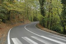
| Les 17 tournants | Senlisse - Les Essarts |
 | |
| Les Vaux de Cernay | |
24.7 km (about 32 min)
| Stage | Distance | Zoom crossing |
Research radius : 100 km
| Length | Distance / Active road | Mark |
| Going to ardon from N20 | 6.3 km | 95 km | 3/5 |
| Sur 91 direction barbizon | 43.9 km | 39 km | 3/5 |
| Archeres la foret - Arbonne la foret | 7.8 km | 50 km | 2.9/5 |
| Petite route parallèle a N20 | 9.1 km | 95 km | 2.9/5 |
| Saint Arnoult - Mauzaize | 51.3 km | 11 km | 2.9/5 |
| Haute Normandie - le long de la Varenne | 58 km | 87 km | 2.8/5 |
| Vallée de Chevreuse: Saint Lambert - Milon la Chapelle | 4.7 km | 2 km | 2.8/5 |
| Eure et Risle | 93.1 km | 56 km | 2.8/5 |
| Nord Seine et marne, Sud Aisne - Meaux / Chateau-Thierry | 65 km | 67 km | 2.6/5 |
| Entre 95 et 60 | 84.6 km | 41 km | 2.6/5 |
| Saint Hilaire les Andrésis - RN60 La Grande Halte | 16.7 km | 99 km | 2.5/5 |
| Vers le Drouais | 10.4 km | 22 km | 2.5/5 |
| Nord 77 | 50.1 km | 60 km | 2.5/5 |
| D7 Belbeuf - Saint jacques sur Darnétal | 12.5 km | 99 km | 2.5/5 |
| D7 Belbeuf | 3.5 km | 99 km | 2.5/5 |
| Loiret, Pithiviers - Puiseaux | 16.6 km | 58 km | 2.2/5 |
| Côte de bonniére | 3.2 km | 49 km | 2.2/5 |
| Vexin Français | 34 km | 34 km | 2.1/5 |
| Perche National park (Dreux - Mortagne) | 68.8 km | 46 km | 2/5 |
| Bréval / Bonniére | 13.1 km | 43 km | 2/5 |
| Côte de Vernon | 4.6 km | 58 km | 1.9/5 |
Research radius : 100 km
| Type | Distance / Active road | Mark | Zoom |
| Le chat chocolat | Bed and breakfast | 101 km | 2.7/5 |
|
There is 1 opinion about this road.
Author marks : Thomas |
|
General mark : 1.9/5 |
Surfacing : 3.5/5 |
Curves : 2.5/5 |
Lanscapes : 1.5/5 |
Speed controls : 0.5/5 |
Traffic : 1.5/5
|
Name : Bigloof |
Date : january 29th 2011
|
General mark : 1.7/5 |
Surfacing : 4/5 |
Curves : 2.5/5 |
Landscapes : 1/5 |
Speed controls : 0.5/5 |
Traffic : 1/5
|
Route sympathique pour se dégourdir les roues u n dimanche matin. A éviter quand il fait beau en week end (beaucoup de moto, des cyclistes et des képis). |
|
